

Polar Vs Cartesian Coordinates
School teaching methodology the world over is primarily based on cartesian coordinate system. In this system all concepts/ diagrams are explained on two dimensional flat blackboards, papers and digital screens.

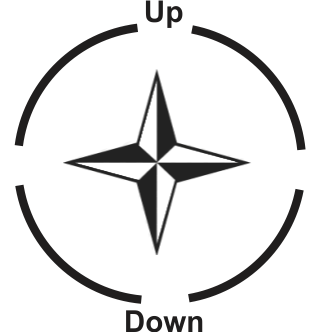
For example, cardinal points i.e. directions North, South, East and West are drawn/ explained with horizontal (sleeping) and vertical (standing) lines as represented above. Such diagrams create confusions in the minds of young learners. For example, most of the students interpret the given diagram as North direction being up in the sky which is not true at all. Astronomy primarily is a two dimensional curved surface subject. A planetarium is a model of the sky as it is dome-shaped and the real sky is also dome-shaped (half of the celestial sphere). A planetarium creates observational scenarios like horizon being parallel to the ground with directions N/S/E/W on it. The students inside the Digisky™ planetarium can very easily translate/ correlate their digital sky simulation observations into mathematics. Full dome Digisky™ digital planetarium simplifies complicated and time consuming astronomy concepts/ observations so that students can easily understand them and that too at an early age.
Progressive Polar Topics for schools K12 :
| S.No. | Grids | Events | Motions | Ancient Sky Cultures |
|---|---|---|---|---|
| 1. | Horizon | Meteors | Diurnal | Greek Directions N/S/E/W |
| 2. | Meridian | Eclipses | Synodic | Hindu |
| 3. | Ecliptic | Occultation | Annual | Egyptian |
| 4. | Latitude/Longitude | Transits | Sidereal | Chinese |
| 5. | Celestial Equator/ Sphere | Conjunctions | Retrograde | Inuit |
| 6. | Circumpolar | Planetary Alignments | Precession | a lot more... |
| 7. | Tropics | Proper Motion | ||
| 8. | Altitude and Azimuth | |||
| 9. | Universal: Right Ascension and Declination | |||
| 10. | Galactic | |||
| 11. | Analemma |